changegen: OSM Changefiles from PostGIS Tables
Many workflows based on OpenStreetMap data use PostGIS to enable spatial operations on these data at planetary scale. Expressing modifications, additions, or deletions to these data is sometimes necessary: for example, to communicate those changes to another system or workflow without access to the PostGIS instance.
changegen is a command line utilty that creates (optionally gzipped) OSM Changefiles from PostGIS tables. Changefiles can then be applied to existing OSM extracts to create new extracts containing the modifications described in the changefile.
Things changegen can do:
Translate from PostGIS
GEOMETRYto OpenStreetMap XML formats (Ways,Nodes). (NB: OnlyPolygon,PointandLineStringdata types are currently supported).Create new
Polygons(e.g. closedWaysorRelations) orLineStrings(WaysandNodes) from objects in PostGIS tables, with corresponding schema as OSM tagsEnsure that new Ways are properly “network-noded” : e.g. that they share nodes at intersections with both existing and new geometries. This is important for e.g. ensuring accurate network topology. This also includes modifying existing
Waysto include these noded intersections. (NB: Intersections withPolygonobjects is not currently supported.)Modify the metadata of
Waysin an existing OSM extract.Delete any OSM object specified by an
osm_idcolumn in a PostGIS table.
Example Usage Scenario
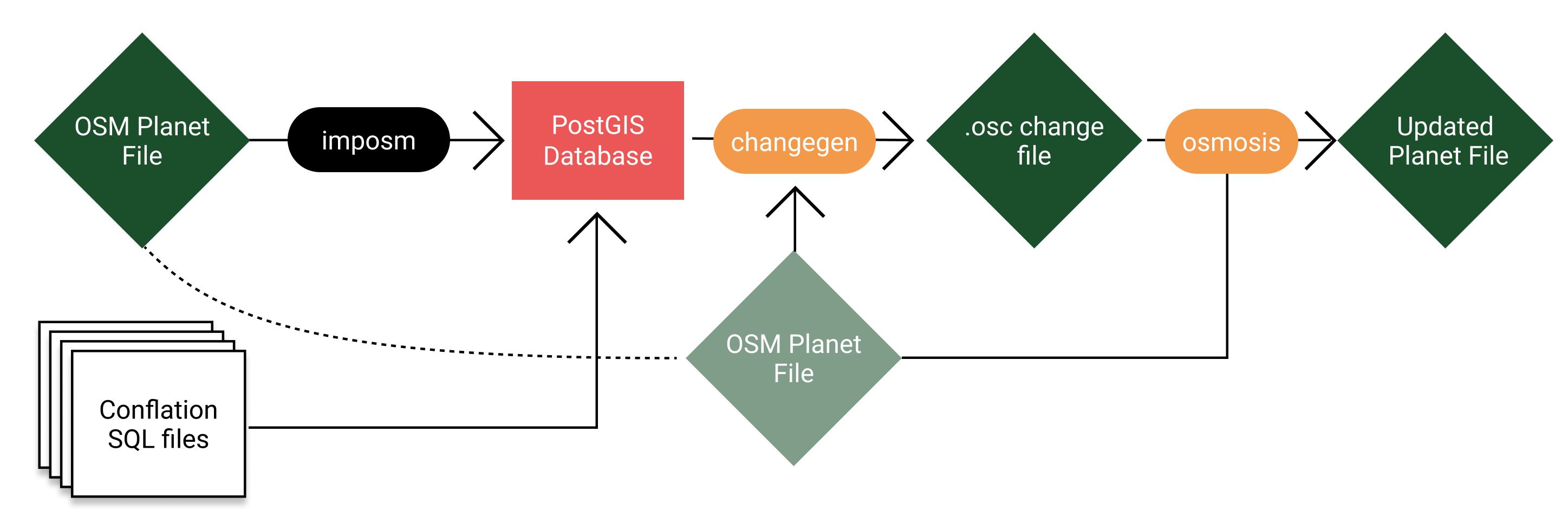
In some workflows, it is common to want to modify the data in an OSM Planet file programmatically. For example, to standardize the set of tags for a given class of OSM objects, or to used third-party data to modify OSM objects regionally. PostGIS is a compelling tool for this kind of processing, as it scales well to large datasets and has fast and flexible spatial operations. In many cases, however, it is desirable to have an OSM Planet file as the result of this geoprocessing, rather than a set of PostGIS tables.
This is why we developed changegen. This tool enables the creation of OSM Changefiles that describe modifications to an existing source OSM Planet file. These modifications are sourced from PostGIS tables, developed using a tool like imposm and custom SQL. Changegen takes care of making sure that intersections are properly noded, that PostGIS geospatial types are converted accurately to OSM types, managing OSM IDs for new and modified objects. At the end of the workflow, the changefile that’s produced by Changegen (derived from the original OSM file and the PostGIS database tables specified), can be applied to the original planet file (using a tool like osmosis ), to obtain an OSM Planet file that contains the modifications performed via the PostGIS database.
Installation
changegen is not available on pip but is pip -installable:
git clone https://github.com/trailbehind/changegen.git
pip install -e changegen
changegen depends on: click, tqdm, osmium, shapely, gdal, lxml, psycopg2, pyproj, and rtree.